


Emerald Coast Utilities Authority Utilizes GPS for Efficient Hurricane Recovery
公司规模
Mid-size Company
地区
- America
国家
- United States
产品
- Trimble GeoXT
- Windows Mobile
- TerraSync software
- GPS Pathfinder Office software
技术栈
- GPS Technology
- Geographic Information System (GIS)
- Real-time Differential Correction
实施规模
- Enterprise-wide Deployment
影响指标
- Cost Savings
- Environmental Impact Reduction
- Productivity Improvements
技术
- 传感器 - 全球定位系统
- 应用基础设施与中间件 - 数据交换与集成
适用行业
- 公用事业
- 城市与自治市
适用功能
- 设施管理
- 维护
用例
- 资产健康管理 (AHM)
- 基础设施检查
- 远程资产管理
服务
- 系统集成
- 培训
关于客户
The Emerald Coast Utilities Authority is a key organization responsible for maintaining the largest water, wastewater, and sanitation systems in Escambia County, Florida. Located in Pensacola, the authority serves a population of nearly 300,000 residents and is tasked with ensuring the functionality and safety of essential utility services. Given its location on the Gulf of Mexico, the area is prone to severe weather events, including hurricanes, which pose significant challenges to infrastructure management. The authority's proactive approach to adopting GPS technology highlights its commitment to improving operational efficiency and disaster recovery capabilities.

挑战
In 1995, Hurricane Opal caused significant damage to Pensacola, Florida, with utility workers struggling to locate buried assets using metal detectors and paper maps. This led to inefficiencies and further damage during recovery efforts. Nine years later, Hurricane Ivan struck with even greater force, threatening to repeat the same challenges. The Emerald Coast Utilities Authority needed a more effective way to manage and recover utility assets buried under debris and sand after such natural disasters.
解决方案
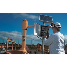
To address the challenges posed by hurricanes, the Emerald Coast Utilities Authority adopted GPS technology to map and record the locations of utility assets. They selected Trimble GeoXT rugged GPS handheld receivers with Windows Mobile software to collect spatially accurate data on fire hydrants, manholes, water valves, and meters. Despite limited formal training, the intuitive nature of the technology allowed workers to efficiently gather and store data. This information was later used to precisely locate buried assets after Hurricane Ivan, significantly improving recovery efforts. The authority has since expanded its use of GPS and GIS technology, hiring a GIS specialist and converting paper maps to digital shapefiles for comprehensive asset management.
运营影响
数量效益


Case Study missing?
Start adding your own!
Register with your work email and create a new case study profile for your business.
相关案例.

Case Study
Turning A Stadium Into A Smart Building
Honeywell created what it called the “intelligent system” for the National Stadium in Beijing, China, turning the venue for the opening and closing events at the 2008 Summer Olympics into a “smart building.” Designed by highly controversial artist Ai Weiwei, the “Bird’s Nest” remains one of the most impressive feats of stadium architecture in the world. The 250,000 square meter structure housed more than 100,000 athletes and spectators at a time. To accommodate such capacity, China turned to Honeywell’s EBI Integrated Building Management System to create an integrated “intelligent system” for improved building security, safety and energy efficiency.

Case Study
IoT Solutions for Smart City | Internet of Things Case Study
There were several challenges faced: It is challenging to build an appliance that can withstand a wide range of voltage fluctuations from as low at 90v to as high as 320v. Since the device would be installed in remote locations, its resilience was of paramount importance. The device would have to deal with poor network coverage and have the ability to store and re-transmit data if networks were not available, which is often the case in rural India. The device could store up to 30 days of data.

Case Study
Automation of the Oguz-Gabala-Baku water pipeline, Azerbaijan
The Oguz-Gabala-Baku water pipeline project dates back to plans from the 1970’s. Baku’s growth was historically driven by the booming oil industry and required the import of drinking water from outside of the city. Before the construction of the pipeline, some 60 percent of the city’s households received water for only a few hours daily. After completion of the project, 75 percent of the two million Baku residents are now served around the clock with potable water, based on World Health Organization (WHO) standards. The 262-kilometer pipeline requires no pumping station, but uses the altitude differences between the Caucasian mountains and the capital to supply 432,000 m³/d to the Ceyranbatan water reservoir. To the people of Baku, the pipeline is “the most important project not only in 2010, but of the last 20 years.”
Case Study
GPRS Mobile Network for Smart Metering
Around the world, the electricity supply industry is turning to ‘smart’ meters to lower costs, reduce emissions and improve the management of customer supplies. Smart meters collect detailed consumption information and using this feedback consumers can better understand their energy usage which in turn enables them to modify their consumption to save money and help to cut carbon emissions. A smart meter can be defined in many ways, but generally includes an element of two-way communication between the household meter and the utility provider to efficiently collect detailed energy usage data. Some implementations include consumer feedback beyond the energy bill to include online web data, SMS text messages or an information display in consumers’ premises. Providing a cost-effective, reliable communications mechanism is one of the most challenging aspects of a smart meter implementation. In New Zealand, the utilities have embraced smart metering and designed cost effective ways for it to be implemented. The New Zealand government has encouraged such a move to smart metering by ensuring the energy legislation is consistent with the delivery of benefits to the consumer while allowing innovation in this area. On the ground, AMS is a leader in the deployment of smart metering and associated services. Several of New Zealand’s energy retailers were looking for smart metering services for their residential and small business customers which will eventually account for over 500,000 meters when the multi-year national deployment program is concluded. To respond to these requirements, AMS needed to put together a solution that included data communications between each meter and the central data collection point and the solution proposed by Vodafone satisfied that requirement.
.png)
Case Study
Smart Street Light Network (Copenhagen)
Key stakeholders are taking a comprehensive approach to rethinking smart city innovation. City leaders have collaborated through partnerships involving government, research institutions and solution providers. The Copenhagen Solutions Lab is one of the leading organizations at the forefront of this movement. By bringing together manufacturers with municipal buyers, the Copenhagen Solutions Lab has catalyzed the development and deployment of next-generation smart city innovations. Copenhagen is leveraging this unique approach to accelerate the implementation of smart city solutions. One of the primary focus areas is LED street lighting.

Case Study
NB-IoT connected smart meters to improve gas metering in Shenzhen
Shenzhen Gas has a large fleet of existing gas meters, which are installed in a variety of hard to reach locations, such as indoors and underground, meaning that existing communications networks have struggled to maintain connectivity with all meters. The meter success rate is low, data transmissions are so far unstable and power consumption is too high. Against this background, Shenzhen Gas, China Telecom, Huawei, and Goldcard have jointly trialed NB-IoT gas meters to try and solve some of the challenges that the industry faces with today’s smart gas meters.
